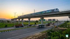

Prime Minister Narendra Modi inaugurated the 213-kilometre-long Delhi-Dehradun Economic Corridor on April 14, 2026, marking a transformative shift in North India’s infrastructure landscape. Built at an investment exceeding 12,000 crore, the expressway slashes the travel duration between the national capital and Dehradun from six hours to just 2.5 hours. This access-controlled project stands as a benchmark for sustainable development, featuring specialized infrastructure to protect the region’s rich biodiversity.
Redefining Regional Connectivity: An Overview
The Delhi-Dehradun Economic Corridor is a flagship project of the National Highways Authority of India (NHAI), designed to provide seamless connectivity between Delhi, Uttar Pradesh, and Uttarakhand. Operating under the Ministry of Road Transport and Highways (MoRTH), the corridor is a six-lane, access-controlled expressway that bypasses congested urban centres to ensure a design speed of 100 kilometres per hour. It effectively links the national capital with major Western Uttar Pradesh cities such as Baghpat, Shamli, and Saharanpur, before terminating in Dehradun.
A Phased Breakdown of the Corridor
To manage its vast length and geographical diversity, the project was executed in four distinct phases. Starting from the Akshardham Temple in Delhi, the expressway incorporates both brownfield upgrades and greenfield stretches.
| Phase | Stretch | Distance | Key Features |
|---|---|---|---|
| Phase 1 | Delhi to Baghpat | 32 km | 12-lane configuration with 6.4 km elevated section |
| Phase 2 | Baghpat to Saharanpur | 118 km | Greenfield stretch bypassing major towns |
| Phase 3 | Saharanpur to Ganeshpur | 40 km | Upgrade of existing infrastructure |
| Phase 4 | Ganeshpur to Dehradun | 20 km | Passes through eco-sensitive Shivalik forest |
In addition to the main corridor, two significant spur routes have been developed to enhance regional integration. The Saharanpur–Roorkee–Haridwar spur connects pilgrims to the holy city of Haridwar, while the Ambala–Shamli expressway provides a vital link between Uttar Pradesh and Haryana.
Environmental Engineering: Asia’s Longest Wildlife Corridor
One of the most notable features of the Delhi-Dehradun Economic Corridor is its commitment to ecological preservation. The final 20-kilometre stretch passes through the Shivalik forest division and the Rajaji National Park, necessitating innovative engineering solutions to prevent habitat fragmentation.
The project boasts a 12-kilometre-long elevated corridor, currently the longest of its kind in Asia. This structure maintains an average height of six to seven metres, allowing flagship species like the Asian Elephant and Indian Leopard to move freely beneath the highway. To further minimize the impact on the forest ecosystem, the corridor is equipped with sound and light barriers to shield wildlife from vehicular noise and headlights.
Near the Daat Kali temple, the project includes a 340-metre-long tunnel designed to avoid disturbing the surface terrain. Additionally, the expressway incorporates eight dedicated animal passes and two specialized 200-metre-long elephant underpasses. Collaborative studies by the Wildlife Institute of India (WII) and NHAI have already confirmed the success of these corridors through camera trap monitoring.
Strategic and Economic Significance
The inauguration of this corridor is a watershed moment for the regional economy of Uttarakhand and Western Uttar Pradesh. By slashing travel time from six hours to 2.5 hours, the expressway makes the hill state more accessible for short-duration tourism and weekend getaways from the National Capital Region (NCR). This is expected to provide a significant boost to the hospitality sector in destinations like Mussoorie, Rishikesh, and Haridwar.
Beyond tourism, the corridor serves as a major logistical backbone. It facilitates the faster movement of agricultural produce and industrial goods, reducing freight costs and fuel consumption. The project is also integrated with an Advanced Traffic Management System (ATMS), which uses real-time data to monitor traffic flow, detect incidents, and enhance commuter safety. Furthermore, the corridor’s development has acted as an employment catalyst, creating thousands of jobs in the construction and logistics sectors.
About Rajaji National Park
The corridor’s passage through Rajaji National Park highlights the importance of this protected area in India’s conservation landscape. Established as a national park in 1983, it was formed by amalgamating three pre-existing sanctuaries: Rajaji, Motichur, and Chilla. The park is named after the legendary freedom fighter and the first Indian Governor-General, C. Rajagopalachari, who was fondly known as ‘Rajaji’.
Located at the transition zone between the Shivalik hills and the Indo-Gangetic plains, the park was granted the status of a Tiger Reserve in 2015. It is the second tiger reserve in Uttarakhand, following the Jim Corbett Tiger Reserve. Geographically, the park is divided into western and eastern sectors by the Ganga River. It is most famous for its population of Asian Elephants, marking the north-western limit of their habitat in India. Other key species include the Tiger, Leopard, and the Goral (mountain goat).
Key Takeaways
- The Delhi–Dehradun Economic Corridor is a 213-kilometre-long expressway built at a cost of over ₹12,000 crore.
- The project reduces travel time between Delhi and Dehradun from six hours to 2.5 hours.
- It features a 12-kilometre-long elevated wildlife corridor through Rajaji National Park, which is currently the longest in Asia.
- The National Highways Authority of India (NHAI) implemented the project under the Ministry of Road Transport and Highways (MoRTH).
- Rajaji National Park was established in 1983 and was later designated as a Tiger Reserve in 2015.
- The corridor includes a 340-metre-long tunnel near the Daat Kali temple and specialized 200-metre-long elephant underpasses.