

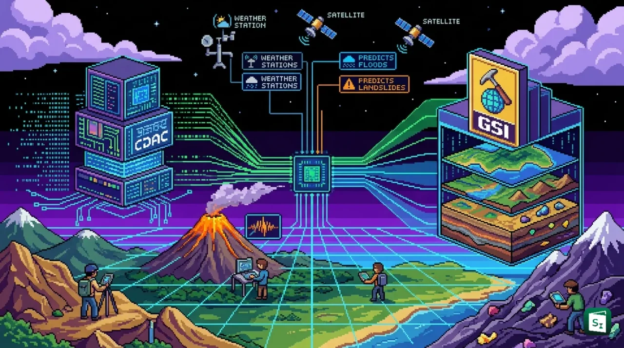
The Centre for Development of Advanced Computing (C-DAC), an autonomous body under the Ministry of Electronics and Information Technology (MeitY), and the Geological Survey of India (GSI) signed an umbrella Memorandum of Understanding (MoU) on 4 August 2026 to deepen collaboration in geoscience, mineral exploration and disaster management. The agreement pairs C-DAC’s High-Performance Computing (HPC) strengths with GSI’s geological expertise to tackle complex subsurface exploration challenges using next-generation digital technologies. The pact directly supports India’s push for critical minerals and self-reliance in disaster forecasting, both of which are central to the country’s economic and strategic priorities.
Who Are the Two Partners?
C-DAC: India’s Supercomputing Pioneer
C-DAC was established in November 1988 as an autonomous scientific research organisation of the Government of India, under what is now the Ministry of Electronics and Information Technology. It came into being after the United States denied India access to its supercomputers, prompting New Delhi to build its own high-performance computing capability. The organisation, headquartered in Pune, delivered the PARAM 8000 in 1991, India’s first indigenously developed supercomputer, a milestone that demonstrated the country could compete on its own in advanced computing.
Today C-DAC works across several technology domains, including High-Performance Computing (HPC), artificial intelligence (AI), multilingual computing, professional electronics, cyber security and health informatics. It has centres in cities such as Bengaluru, Chennai, Hyderabad, Kolkata, Noida and Thiruvananthapuram. Under the National Supercomputing Mission, a joint initiative of the Department of Science and Technology and MeitY launched in 2015, C-DAC has developed the PARAM series of supercomputers and India’s dedicated AI supercomputer, AIRAWAT, which was ranked among the world’s top machines for AI workloads.
GSI: The Nation’s First Geological Agency
The Geological Survey of India is one of the oldest scientific organisations in the country. It was established on 4 March 1851, initially to explore coal deposits for the railways, and is the principal agency responsible for geological mapping and mineral resource assessment. It functions under the Ministry of Mines with its headquarters in Kolkata.
GSI conducts systematic geoscientific surveys, identifies mineral reserves, prepares geological and geotechnical maps, and monitors natural hazards such as landslides and earthquakes. It plays a leading role in the exploration of critical and strategic minerals and works closely with the National Disaster Management Authority (NDMA) on hazard zonation and early warning efforts.
What the MoU Covers
The MoU was signed at Electronics Niketan in New Delhi by E Magesh, Director General of C-DAC, and Pradeep Singh, Additional Director General of GSI, in the presence of S Krishnan, Secretary of MeitY. As an umbrella agreement, it provides a broad framework under which specific projects can be taken up later, rather than committing to a fixed list of deliverables on day one.
High-Resolution 3D Subsurface Mapping
The core of the partnership is combining AI and HPC to process large geophysical datasets collected by GSI. This will enable high-resolution three-dimensional (3D) subsurface mapping, which is the process of building a digital picture of rock layers, faults and mineral bodies deep below the ground. Such mapping is far more accurate than traditional two-dimensional survey methods.
Predictive Modelling for Mineral Targeting
AI models will help identify where mineral deposits are most likely to be found. This is known as predictive modelling for mineral targeting, and it allows geologists to prioritise drilling and sampling in the most promising areas instead of exploring blindly. The technique is expected to shorten exploration timelines and cut the cost of discovering new deposits.
A Dedicated Geological Large Language Model
Decades of exploration have produced enormous volumes of unstructured geological records, including field notes, maps, borehole logs and old survey reports held in GSI’s archives. The partnership plans to digitise and process this material into a domain-specific Large Language Model (LLM), an AI system trained on geological knowledge that can answer queries, flag patterns and help scientists retrieve insights that would otherwise take years to locate manually.
Disaster Management
The agreement goes beyond exploration to cover disaster risk reduction. The two agencies will use Synthetic Aperture Radar (SAR), a satellite-based imaging technique that can capture ground movement even through cloud cover, to monitor landslides at slope scale. This work will feed into early warning systems and detailed studies of Glacier Lake Outburst Floods (GLOF), which are among the most destructive climate-linked hazards in the Indian Himalayas.
Why Critical Minerals Matter
A stated aim of the MoU is to accelerate the discovery of critical minerals and Rare Earth Elements (REE). Critical minerals are those essential for modern technology, defence and clean energy, but whose supply is concentrated in very few countries. Rare earth elements, a group of 17 chemically similar metals, are a subset of these and are used to make permanent magnets for electric vehicle motors, wind turbines and electronics.
India faces a significant import dependency in this area. The country relies on imports for nearly all of its lithium, cobalt and nickel, and a large share of its rare earth processing is carried out abroad, with China dominating global refining capacity. This makes the mineral supply chain vulnerable to geopolitical disruption, which is why securing domestic sources has become a strategic priority.
The National Critical Mineral Mission
The umbrella MoU fits directly into the National Critical Mineral Mission (NCMM), approved by the Union Cabinet in January 2025 with an expenditure outlay of ₹16,300 crore and an expected additional investment of about ₹18,000 crore by public sector undertakings over seven years. The mission covers the entire value chain, from exploration and mining to beneficiation, processing and recycling.
Under the mission, GSI has been tasked with conducting 1,200 exploration projects between 2024-25 and 2030-31. A Ministry of Mines committee identified 30 critical minerals for India, with 24 of these added to Part D of Schedule I of the Mines and Minerals (Development and Regulation) Act, 1957, which gives the central government the exclusive right to auction mining leases and composite licences for them. The MMDR Amendment Act, 2023 made this possible, alongside new fast-track approvals and an exploration licence regime designed to attract private investment.
Landslides and GLOFs: The Himalayan Threat
The disaster management component of the MoU responds to a well-documented and growing risk. According to GSI estimates, about 0.42 million square kilometres, or roughly 12.6 percent of India’s land area, is prone to landslides. The most vulnerable regions are the Himalayas, the northeastern hill ranges and the Western Ghats, all of which see frequent slope failures triggered by heavy rain, seismic activity and human construction.
The Himalayan region is especially exposed to a distinct threat known as a Glacier Lake Outburst Flood (GLOF). A glacial lake forms when melting glacier ice is held back by a natural dam of moraine, the debris left behind by a retreating glacier. If that dam collapses, the lake releases a sudden, catastrophic wall of water downstream. Climate change is accelerating glacier melt, making these lakes larger and riskier.
Recent GLOF Disasters
The 2023 Sikkim flash floods offered a stark reminder of the danger. On 3-4 October 2023, the South Lhonak glacial lake in Sikkim burst its banks after a slope collapse triggered a massive wave that overwhelmed the Teesta III hydroelectric dam. The resulting flood killed dozens of people, left many more missing, and destroyed bridges, roads and infrastructure along the Teesta river valley.
Earlier, the Kedarnath disaster of June 2013 in Uttarakhand, triggered by a cloudburst and subsequent flash floods, caused thousands of deaths and became a landmark case study in mountain disaster management. The 2024 Wayanad landslides in Kerala similarly demonstrated that early warning capability for slope failures remains incomplete, even in areas that are well monitored.
What the Partnership Can Add
The MoU envisages using SAR-based monitoring and AI analysis to detect early signs of slope instability and lake expansion. This connects to existing national efforts. The National Disaster Management Authority has identified high-risk glacial lakes for monitoring, and the National Glacial Lake Outburst Flood Risk Mitigation Project (NGRMP), approved with an outlay of ₹150 crore, is being implemented in Arunachal Pradesh, Himachal Pradesh, Sikkim and Uttarakhand. The Central Water Commission currently monitors over 900 glacial lakes and water bodies across the country.
Significance of the MoU
Economic Security and Supply Chain Resilience
The most immediate significance is in the minerals space. India’s energy transition plans, including the target of achieving 50 percent of electric power capacity from non-fossil sources by 2030 and net zero emissions by 2070, depend on reliable supplies of lithium, cobalt, nickel and rare earths. Faster, cheaper discovery of these minerals domestically reduces the need for imports and insulates the economy from price swings and geopolitical shocks. The MoU also advances the spirit of Aatmanirbhar Bharat by building indigenous capability in both supercomputing and earth science.
Technological Self-Reliance
The deal keeps critical computational work in India. By using C-DAC’s indigenous HPC systems to process geophysical data, the project reduces dependence on foreign cloud platforms and foreign models. The planned geological Large Language Model would be among the first domain-specific AI tools built for an Indian scientific agency on domestic compute infrastructure, an important step for the country’s AI ambitions.
Better Disaster Preparedness
For the disaster component, even incremental improvements in early warning can save lives and protect expensive infrastructure. Landslide-prone stretches of national highways, hydropower projects and hill towns stand to gain from slope-level SAR monitoring. GLOF studies feed directly into dam safety reviews, evacuation planning and settlement policy in the Himalayas.
The Way Forward
The umbrella nature of the MoU means the two organisations will now negotiate specific project agreements under its framework. Early candidates are expected to include joint work on AI-based mineral targeting in identified Obvious Geological Potential (OGP) zones, SAR-based landslide monitoring pilots in the Himalayan states, and the digitisation of GSI’s archival records into the geological language model.
The collaboration also sits within a wider ecosystem of government programmes, including the National Supercomputing Mission, the IndiaAI Mission and the National Critical Mineral Mission. If executed well, it could become a template for how scientific agencies in India pool computing power and domain knowledge to solve problems that neither could handle alone.
Key Takeaways
- C-DAC and the Geological Survey of India (GSI) signed an umbrella MoU on 4 August 2026 at Electronics Niketan, New Delhi, to collaborate on geoscience, mineral exploration and disaster management.
- C-DAC, established in November 1988 under MeitY and headquartered in Pune, developed the PARAM 8000 in 1991, India’s first indigenously built supercomputer.
- GSI, established on 4 March 1851 and headquartered in Kolkata, functions under the Ministry of Mines as India’s principal agency for geological mapping and mineral resource assessment.
- The partnership will use AI and High-Performance Computing for 3D subsurface mapping, predictive modelling for mineral targeting, and a domain Large Language Model built from GSI’s geological archives.
- Disaster work will cover Synthetic Aperture Radar (SAR) based landslide monitoring, early warning systems and GLOF studies, following disasters like the 2023 South Lhonak GLOF in Sikkim.
- The MoU advances the National Critical Mineral Mission, approved in January 2025 with an outlay of ₹16,300 crore, under which GSI is to carry out 1,200 exploration projects from 2024-25 to 2030-31.