
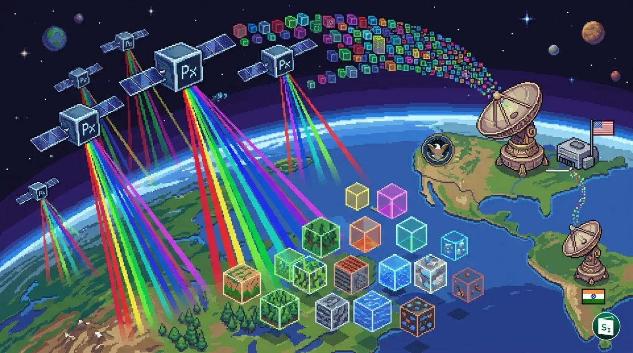
Pixxel, an Indian space technology enterprise, has entered into a contract with the U.S. National Reconnaissance Office (NRO) to develop advanced hyperspectral remote sensing capabilities. The agreement, managed under the NRO Commercial Systems Program Office (CSPO), will leverage Pixxel’s Firefly satellite constellation to identify materials and chemical processes from space. This collaboration marks a milestone for the Indian space startup ecosystem as it integrates with the remote sensing architecture of the United States.
Strategic Integration of Hyperspectral Technology
The contract is part of the Strategic Commercial Enhancements initiative by the National Reconnaissance Office (NRO), which aims to diversify the agency’s remote sensing portfolio by incorporating emerging commercial technologies. By partnering with Pixxel, the NRO intends to evaluate and integrate hyperspectral imagery (HSI) into its existing intelligence and surveillance frameworks. This move reflects a broader shift in space reconnaissance towards a hybrid architecture that combines government owned assets with agile, commercial satellite systems.
Managed by the Commercial Systems Program Office (CSPO), the agreement focuses on demonstrating the unique spectral insights provided by Pixxel’s constellation. These insights allow analysts to characterize materials and monitor environmental conditions that are typically invisible to conventional multispectral or panchromatic sensors. The collaboration will explore how these capabilities can enhance global monitoring and tactical situational awareness.
The Firefly Constellation: Pixxel’s Eye in the Sky
Pixxel’s Firefly constellation represents a major advancement in commercial Earth observation. As of May 2026, the constellation is fully operational, following a series of successful launches throughout 2025. These satellites are designed to capture hyperspectral data across more than 135 spectral bands at a spatial resolution of approximately 5 meters.
Unlike traditional satellites that capture data in only a few broad color bands, hyperspectral sensors break down the light spectrum into hundreds of narrow, contiguous bands. This allows for the creation of a spectral fingerprint for every object on Earth, enabling the identification of specific chemical compositions, plant health, and material types with high precision.
Technical Specifications of Firefly Satellites
| Feature | Specification |
|---|---|
| Spectral Bands | 135 or more contiguous bands |
| Spatial Resolution | Approximately 5 meters |
| Spectral Range | Visible to Near-Infrared (VNIR) |
| Revisit Frequency | Daily global coverage |
| Orbit Type | Sun-Synchronous Orbit (SSO) |
The operational scale of the Firefly constellation enables a 24 hour revisit frequency, meaning the satellites can image any point on the planet every single day. This high temporal resolution is critical for monitoring rapidly changing situations, such as industrial leaks, crop stress, or military movements.
Understanding Hyperspectral Remote Sensing
Hyperspectral remote sensing, often called imaging spectroscopy, is a technique that combines the power of digital imaging and spectroscopy. While a standard camera captures only three primary colors (red, green, and blue), a hyperspectral sensor captures data across a wide range of the electromagnetic spectrum. This dense data provides enough information to identify the exact chemical and physical properties of a target.
Analogy · The Spectral Fingerprint Expand analogy
Think of a standard satellite image as a summary of a book, giving you the general plot. A hyperspectral image is like having the entire text of the book, allowing you to analyze every single word and understand the deepest layers of meaning and detail.
Applications in Defence and Security
In the context of national security and reconnaissance, hyperspectral technology provides several critical capabilities:
- Camouflage Detection: It can distinguish between natural vegetation and man-made camouflage materials, as they reflect light differently in the non-visible parts of the spectrum.
- Chemical and Material Identification: Analysts can identify specific chemical processes, gas leaks, or the composition of industrial materials from orbit.
- Terrain Characterization: The technology helps in mapping soil types and moisture levels, which is vital for determining the trafficability of terrain for military vehicles.
- Environmental Monitoring: It allows for the precise tracking of pollutants, oil spills, and changes in land use with much higher accuracy than traditional imaging.
About Pixxel and the NRO
Pixxel is a Bengaluru based space technology startup founded in 2019 by Awais Ahmed and Kshitij Khandelwal. The company has rapidly emerged as a leader in hyperspectral imaging, launching pathfinder satellites like Anand (TD-1) and Shakuntala (TD-2) before deploying its commercial Firefly constellation. Headquartered in Bengaluru, Pixxel also maintains a strong presence in the United States, with an office in El Segundo, California.
The National Reconnaissance Office (NRO) is a major intelligence agency of the U.S. Department of Defense and a member of the United States Intelligence Community. It is responsible for designing, building, launching, and operating the reconnaissance satellites of the U.S. federal government. The NRO’s Commercial Systems Program Office (CSPO) serves as the primary interface between the agency and the commercial satellite industry, facilitating the integration of innovative private sector capabilities into national security architectures.
This latest contract builds upon a multi-year partnership between Pixxel and the NRO, which began with a 5-year agreement in March 2023. The continued collaboration underscores the U.S. government’s confidence in Pixxel’s technology and the overall maturity of the Indian space-tech sector as a reliable provider of high-end satellite data.
Key Takeaways
- Pixxel, an Indian space technology startup, has secured a new contract from the U.S. National Reconnaissance Office (NRO) in May 2026.
- The agreement is managed under the NRO Commercial Systems Program Office (CSPO) as part of the Strategic Commercial Enhancements initiative.
- The contract focuses on integrating hyperspectral remote sensing data from Pixxel’s Firefly constellation into the NRO’s reconnaissance architecture.
- Pixxel’s Firefly constellation consists of satellites capable of capturing over 135 spectral bands at a 5 meter spatial resolution.
- Hyperspectral imaging allows for the identification of materials and chemical processes by analyzing unique spectral fingerprints across the electromagnetic spectrum.
- Pixxel was founded in 2019 by Awais Ahmed and Kshitij Khandelwal, with its headquarters in Bengaluru, India.